New technology allows us to see wetlands like no eye has seen them before.
Wetlands are lands that are wet for at least part of the year. They provide critical feeding, resting and breeding habitat to many kinds of waterfowl, amphibians and reptiles, fish, small mammals and dragonflies. Thanks to a collaboration between the Forest Preserve District, the Department of Geographic Information Systems (GIS) of the Cook County Bureau of Technology and the US Fish and Wildlife Service, land managers now have an exciting new tool that helps them “see” Cook County wetlands like never before.
Over the past year, private contractors Merrick and Company, along with Galileo Group, Inc., have been flying a Cessna 172 Skyhawk at 5,500 feet in a lawn mower-like pattern of east and west parallel flight lines over all of Cook County. Installed in the fuselage of this small airplane is a hyperspectral imaging system which leaves just enough room for a pilot and a sensor operator. This hyperspectral sensor is not your average camera: about the size of a bread box and weighing about 80 pounds, this ultra-high-tech device is integrated with a high precision Global Positioning System (GPS) and Inertial Measurement Unit. Together, these cutting-edge technologies can collect a three-dimensional data cube consisting of hundreds of images, each representing a different wavelength across the visible and near infrared portion of the electromagnetic spectrum. The device does this all while recording the aircraft’s altitude, speed, longitude, latitude, flight heading, pitch, roll and yaw 100 times per second in order to adjust for the plane’s every wobble and slide, atmospheric interference and even for changes in the angles from which the images are taken.
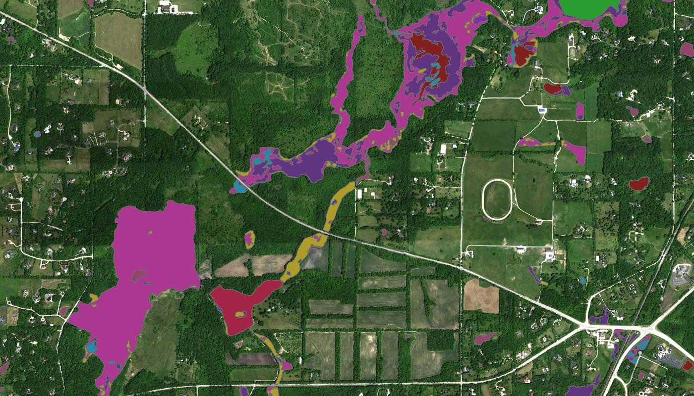
When all the imagery becomes available to ecologists this month, the Forest Preserve District will use it to identify every wetland on its property and better define the boundaries of each. The technology, called hyperspectral imagery, is accurate to one meter, which means the District will be able to determine wetland edges very precisely. The detailed information will be included in the National Wetlands Inventory.
“What’s so cool is that we’re collecting data outside of what we can see,” says Forest Preserve District GIS manager Garret Wais. “The visible spectrum is so narrow. There’s so much more information available when you can go beyond visible light into other areas of the electromagnetic spectrum.”
When the AISA EAGLE hyperspectral sensor takes a “picture”—to call it a picture is really a misnomer — it scans the ground below and collects the reflected light through a lens. It translates the light into a digital signal across dozens of bands within the visible and near-infrared spectrum. Each east-west flight line produces a single “picture” with millions of pixels, each with its own unique spectral signature created by the interaction of light on the objects within that one-by-one-meter pixel.
Once the aerial imagery is collected, a highly trained remote-sensing scientist processes the data by removing distortion and calculating the latitude and longitude of each pixel. Later, this scientist travels by foot to areas already known to be wetlands and uses a handheld computer to take ground measurements. These are then overlain on the aerial imagery and used to extract a “signature” for each of the different wetland types. The scientist creates a spectral library of these signatures and is then able to identify additional wetlands based on the collection of traits found within square-meter pixels. In this way, the spectral library can be used to identify and classify all wetlands found in Cook County. This amazing technology can provide even more detailed insight for land managers by identifying different not only wetland types, but vegetation, soil chemistry, mineralogy, water presence or absence, and a host of other factors.
The Forest Preserve District of Cook County is currently the only Chicago-region natural land management agency using this accurate and powerful imagery. Cook County GIS, a separate government agency from the Forest Preserve District, funded this aerial surveying project of the entire county for use by a wide variety of users. While Cook County GIS’s policy is to provide other government agencies free access to its data, the department recognized early on that the District would be an active stakeholder that would share its expertise and personnel to achieve a highly usable and successful outcome.
Why study our wetlands this way? “It helps us understand the overall mosaic of our ecosystems,” says Wais. “If we can find and protect our surviving wetlands—and a large percentage of Illinois wetlands have been drained or polluted with runoff—then we can increase the likelihood that the species that rely on them can survive. In addition, knowing where things get wet helps as a planning tool. We can better identify areas that regularly get inundated with water that would be unsuitable for trails, facilities or other structures. Lastly, we are taking a snapshot in time of the current state of wetlands in Cook County. This allows us to compare historical data to our results, which guides our decision making for protecting, maintaining and improving wetland areas.”